2016-17 Water Year in Review

In what has become somewhat of a tradition on this blog, I’ll recap the just-concluded 2016-17 water year (a water year runs from Oct. 1 to Sept. 30 of the following year) and touch on some of the factors that influenced storage supplies at Lake McConaughy for hydroelectric generation, irrigation deliveries, groundwater recharge, wildlife habitat and recreation within Central’s project area.
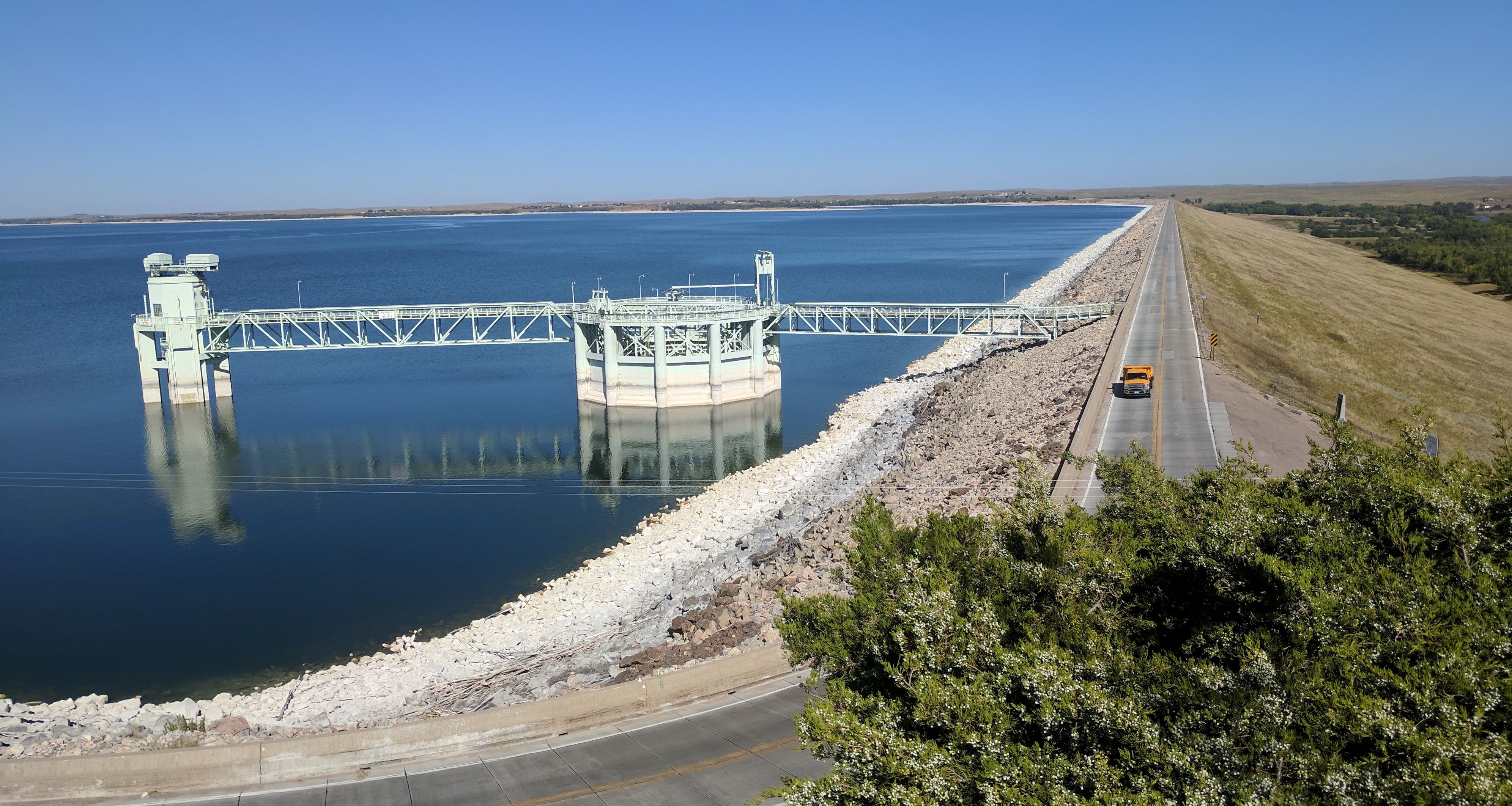
Lake McConaughy, September 21, 2017 at elevation 3248.2 feet (1.27 million acre-feet).
Monthly inflows during the 2016-17 water year were very near the historical median in each of the first six months of the water year. The reservoir got a boost during April when inflows were 152% of the historical median. The 109,809 acre-feet (a-f) of water that flowed into Big Mac during April represents the 13th highest inflows for that month in the reservoir’s 76 years of existence. (It should be noted that some of those April inflows included transfers from the Environmental Account in Wyoming’s Pathfinder Reservoir, which were passed through Kingsley Dam for the benefit of endangered species habitat in the central reach of the Platte River.)
Other months notable for higher than normal inflows and where they rank for that particular month: May (140,948 acre-feet, 13th); June (150,326 acre-feet, 20th); and August (89,462 acre-feet, 10th).
Projections for inflows during May, June and into early summer were optimistic, given that the U.S. Bureau of Reclamation originally intended to release water that was in excess of its North Platte River reservoirs’ capacity to store (called a “spill”). Although the spill didn’t materialize, inflows during May and June still were about double the historical median. In anticipation of the projected spill, Central had increased releases from Lake McConaughy to create sufficient capacity in the reservoir to store the water, rather than pass inflows. Passing inflows through a full reservoir could have contributed to high-water conditions downstream in the Platte Valley. Despite the high early releases, McConaughy was still expected to reach its peak at or near the maximum elevation of 3,265.0 feet above mean sea level.
Then it didn’t.
Blame it on the amount of snowpack in the mountains of Colorado and Wyoming. Accumulation started on a high note, particularly in the upper North Platte Basin where it was about 130% of average as late as February. But experienced water managers will tell you that early snowpack accumulation is not near as important as what happens during the early to mid-spring period. That tends to be the time when more snow with higher water content falls, which usually determines whether runoff will be high, low or somewhere in between.
In this case, snowfall in the upper North Platte Basin kind of petered out and total snowpack ended up below average. In the lower basin (above Glendo Reservoir), snowpack never did reach average levels, finishing at about 90% of average, and melted rather quickly.
In the end, the projections were a little off the mark (Mother Nature is notoriously hard to predict with absolute certainty) and as a result Lake McConaughy peaked at elevation 3,258.1 feet on June 21, within a couple of days of when the “normal” peak elevation occurs. In hindsight, which is, as they saying goes, “always 20/20,” the reservoir would most likely have reached its peak elevation if spring releases were more conservative, but Central was acting on the best available information that called for robust runoff from a snowpack … which didn’t reach expectations.
Nonetheless, total water year inflows amounted to 1,127,049 acre-feet (unofficially), which ranked 22nd in Lake McConaughy’s 76-year history. For comparison, the historical median inflow is 915,275 acre-feet, while the median inflow over the past 30 years is 758,071 acre-feet. It was the third consecutive year in which inflows exceeded 1 million acre-feet, but only the fifth time in the last 18 years that it exceeded the historical median.
Another indicator of good inflows occurred this year when non-irrigation season inflows surpassed the historical median of 572,223 a-f. Non-irrigation season – or the “storage period” when there is no demand for irrigation water – is the period between and including Oct. 1 through April 30. This year’s inflows of 588,344 a-f eclipsed the historical median, but it’s one of only four years since 1987 that this has happened.
As it turned out, lake levels and cooperative weather were just about perfect for visitors to Lake McConaughy. The combination of plenty of water and plenty of beach is hard to beat. Following on the heels of a year in which Lake McConaughy ranked #2 in the state – behind only Omaha’s Henry Doorly Zoo – with more than 1.3 million visitors, the Lake McConaughy State Recreation Area is expected to again top the 1 million visitor-days mark, although final numbers aren’t yet available. One of the highlights from last summer was the record-setting number of visitors over the extended Fourth of July holiday weekend. The Nebraska Game and Parks Commission reported that the 209,813 visitor-days recorded that weekend surpassed the old record of 181,147 set in 2014.
Turning to the irrigation season, the Irrigation Division reported that 162,363 acre-feet of water were diverted into the system during the irrigation season, with average use of 7.2 inches per acre by irrigation customers on Central’s three main irrigation canals, Phelps, E-65 and E-67.
Using delivery data from 1990, 2002 and 2012 – years similar to 2017 in terms of acres, temperatures and rainfall – we see that diversions for irrigation deliveries continue to trend downward over the past 30 years.
The 1990 diversions totaled about 249,000 acre-feet; in 2002 they were around 224,000 acre-feet; and in 2012 – a year particularly noted for lack of summer rainfall – diversions were less than 194,000 acre-feet.
Dave Ford, the Irrigation Division’s manager, attributed the declining irrigation diversions to water conservation efforts and efficiency measures by Central’s customers and within the conveyance system.
“The bottom line,” he said, “is that our customers are growing more crops with less water.”
Over the past 30 years, average diversions into the irrigation canals have dropped from about 225,000 acre-feet/year to around 150,000 acre-feet/year, although that number includes six years during which irrigation customers were allocated less than their full supply of water as a result of an extended drought during the mid-2000s.
I’ll also mention that the 7.2 inches/acre average use was about two inches less than the average over the past 20 years, another indication of efficiency gains and (timely) rainfall. Finally, of the 162,363 acre-feet diverted into the irrigation canals, more than 101,000 acre-feet was documented as going to groundwater recharge in the area during the irrigation season. (Note that Central is also planning off-season recharge efforts with its canals as long as the weather and flows in the river cooperate.)
So all in all, it was a pretty good water year. With all-too-fresh memories of years when inflows failed to surpass 500,000 acre-feet, we are thankful any time they surpass the 1 million mark.
As for the new (2017-18) water year, we’ll have to wait awhile and see. For what it’s worth, the Old Farmer’s Almanac (hey, they’re as accurate as just about anyone else!) forecast for the inter-mountain region — the area where snowmelt feeds the Platte Basin — says, “Winter will be colder than normal, especially in the south, with the coldest periods from late November into early December and in late December, mid-January, and early February. Precipitation will be slightly below normal in the north and above in the south, with above-normal snowfall in both. The snowiest periods will be in early and mid- to late December, mid-January, early and mid-February, and early March. April and May will be warmer and slightly drier than normal.
Finally, upstream storage in the Bureau’s North Platte Reservoirs is in good shape with Pathfinder Reservoir currently at 74% of capacity and Seminoe Reservoir 80% full. That’s a good way to start a new year!
The blog author does not claim to be a hydrologist, but some people think he’s all wet.